


Parts of the UK could be battered with half a month’s worth of rainfall in less than a day, the Met Office warned.
The forecaster said Northern Ireland could experience some of the worst of a heavy spell of rainfall on Sunday evening into Monday.
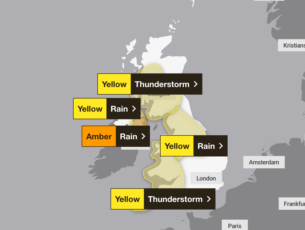
It comes as new amber-level rain warnings were put in place for the eastern counties of Northern Ireland, as well as several counties south of the border.
The warning applies for Antrim, Armagh and Down between 11pm on Sunday until 8am on Monday. But as there remains some uncertainty regarding the extent of the heaviest rain, a wider yellow weather warning for rain remains in place in Northern Ireland from 6pm on Sunday to 6pm on Monday.

The expected rainfall carries a risk of flooding, power cuts and dangerous driving conditions. Forecasters also warn there is a small chance that some communities could be cut off by flooded roads, while fast-flowing or deep floodwater could pose a danger to life.
Met Office forecaster Simon Partridge said: “It looks like Northern Ireland is the place where we could see the most rainfall and certainly the most impactful rainfall. They could see 50 to 75mm of rain within 12 to 18 hours.”
The region records an average of 89mm of rain in July, meaning more than half a month’s rainfall could hit Northern Ireland in less than a day.
Chief meteorologist Andy Page added: “This high intensity rainfall can lead to flooding, with impacts on properties, transport networks and power outages.
“The heavy rain comes at the start of a new working week, so expect disruption to the Monday morning commute and check the flood risk in your area to protect your property.”


A yellow-level thunderstorm warning was in place for the western half of Northern Ireland between midday and 8pm on Sunday.
Across much of Wales and south-west England, the Met Office warned of a “danger to life” as thunderstorms were forecast in the regions on Sunday.
On Monday, the thunderstorm warning moves to much of Scotland and England. It is in place between 3am and 9pm.
UK five-day weather forecast
This evening and tonight:
Rain continues to affect Scotland and Northern Ireland overnight, while further heavy showers spread into the South, but drier with clear spells across Wales and central England. Feeling fresher in the South, but remaining rather muggy for northern areas.
Monday:
Another cloudy, damp start, particularly for the South East and across Northern Ireland. Brighter elsewhere, though showers soon return: heavy, thundery, and with a risk of hail by the afternoon.
Tuesday to Thursday:
Sunny spells and scattered showers remain the theme this week as low pressure continues to bring unsettled conditions. Less showers, more sunshine by Thursday, with temperatures around the seasonal average.


