


Almost 150 flood alerts are in place across the country as the Met Office issued fresh weather warnings for heavy rain and wind after Storm Ingrid battered parts of the UK.
Parts of a historic pier crumbled into the sea in Devon, and a sea wall that protects a railway line in Dawlish was brought down as huge waves and heavy rain lashed the coastline early on Saturday.
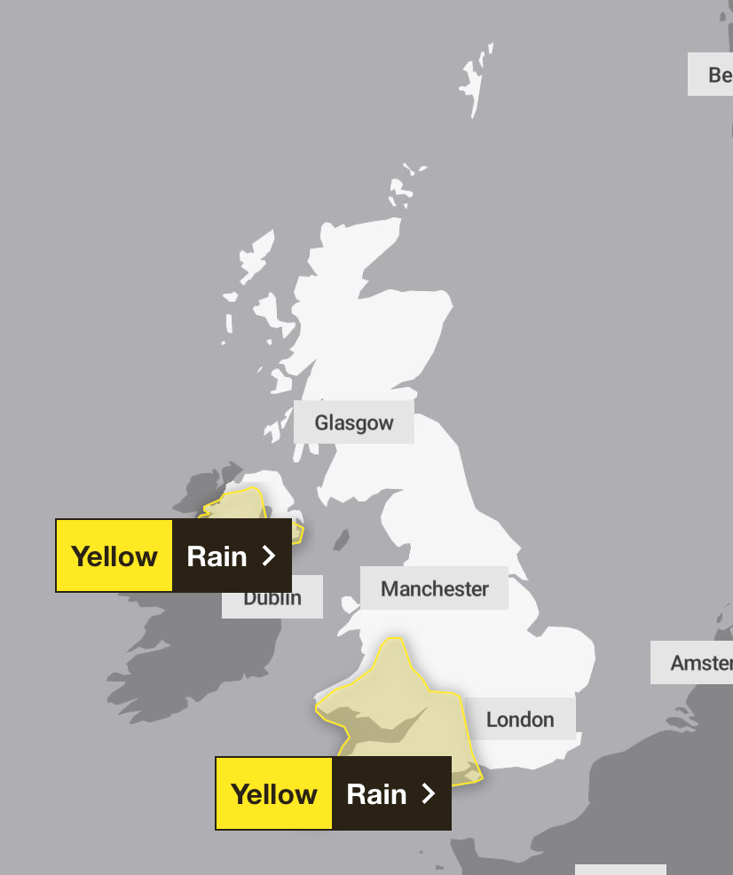
Now, the forecaster has warned that further volatile weather is to come, with yellow warnings for south west, southern and mid Wales on Monday, which has also extends to southern England on Tuesday.
The forecaster warned that homes and businesses could be flooded, some communities could become cut off, and power cuts are possible.

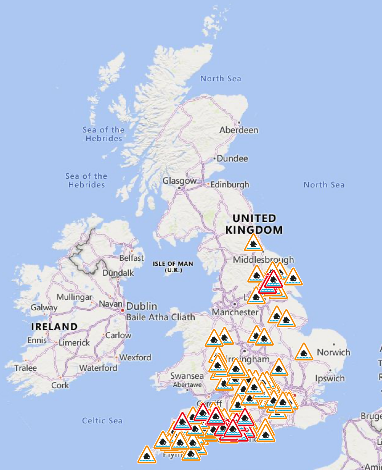
The Environment Agency has issued 113 flood alerts, indicating flooding is possible, and 20 flood warnings, where deluge is expected, across England on Sunday. The Scottish Environment Protection Agency (SEPA) issued seven flood warnings and three flood alerts, while Natural Resources Wales has two alerts in place.
Outbreaks of heavy rain are expected to bring some transport disruption across the south west of England, southern and mid Wales, and some parts of the south east of England. A yellow rain weather warning is in place across the region from 3pm Monday until midday on Tuesday.


Up to 30mm of rainfall is expected widely, with 50-80mm likely across higher ground, especially Dartmoor, Exmoor and Bannau Brycheiniog (Brecon Beacons). With wet conditions prior to this period, the rain will fall onto saturated ground, accentuating flooding impacts in places. Strong southeasterly winds are also likely.
Another yellow rain warning is in place on Monday between 12 and 6pm for County Armagh, County Down, County Fermanagh, County Londonderry and County Tyrone across Northern Ireland. Heavy rain will move northeastwards across the area on Monday afternoon. Up to 20 mm of rain is expected to fall widely, with 20-30mm in a few areas and as much as 40mm over high ground.

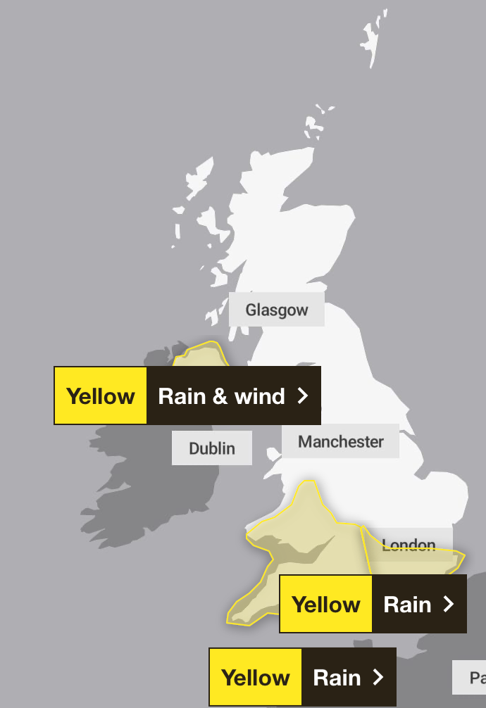
This will become a rain and wind warning on Tuesday, from 2am til 10pm, as rain will also be accompanied by strong east to southeasterly winds, particularly in northern and eastern areas, where peak gusts of 40-50mph are possible inland and potentially 60-70mph along some exposed coasts.
The south east of England will also see a downpour from midnight through to midday on Tuesday, with 15-25mm of rain expected to build up widely across the area. A few areas will potentially see 30-40mm of rainfall and as much as 50mm over some hills.

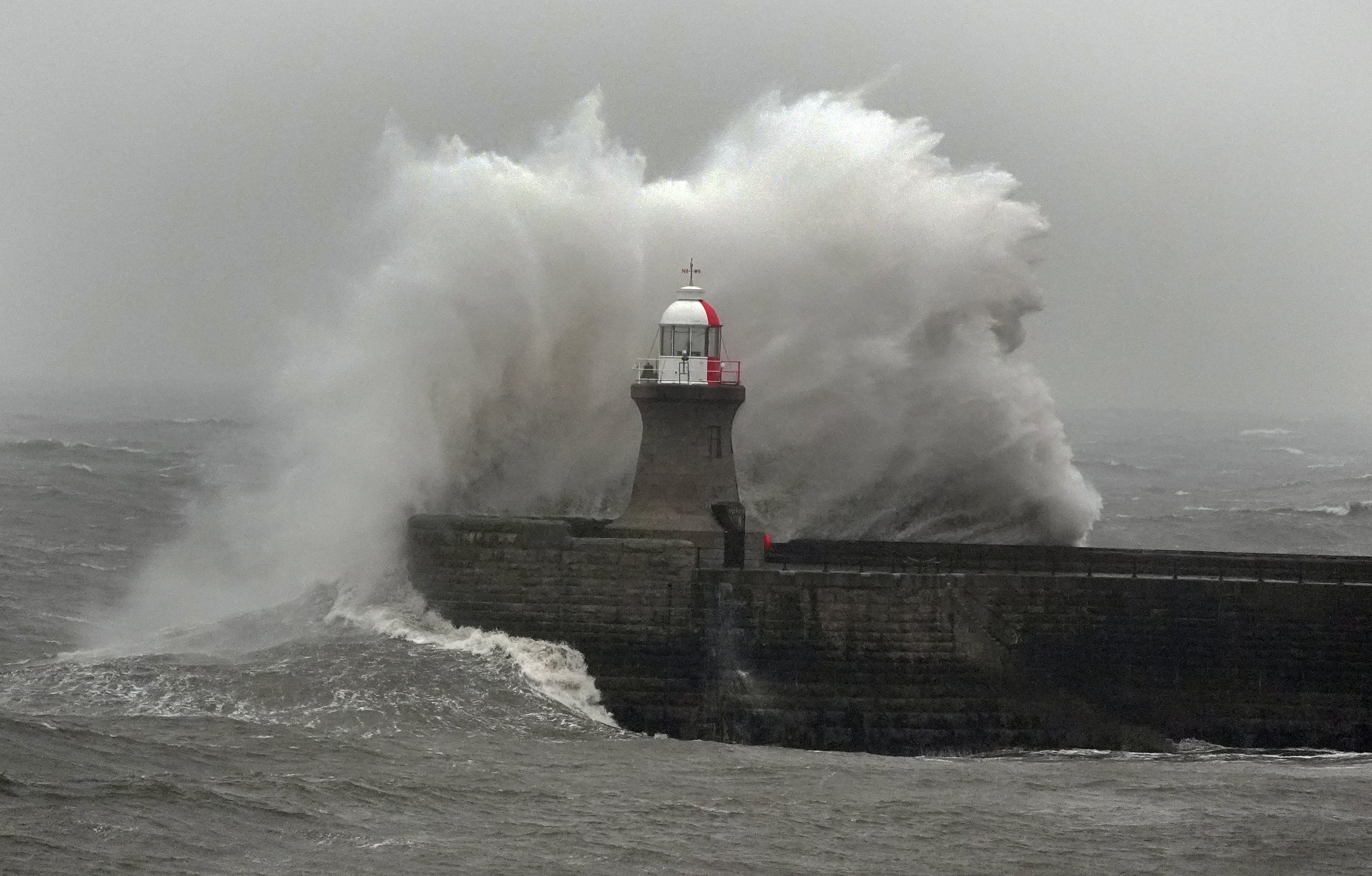
The wet weather continues after Storm Ingrid, so named by the Portuguese Meteorological Service, brought gusts of 45 to 50mph and wet weather, causing structural damage across vast coastal parts of the UK on Friday night.

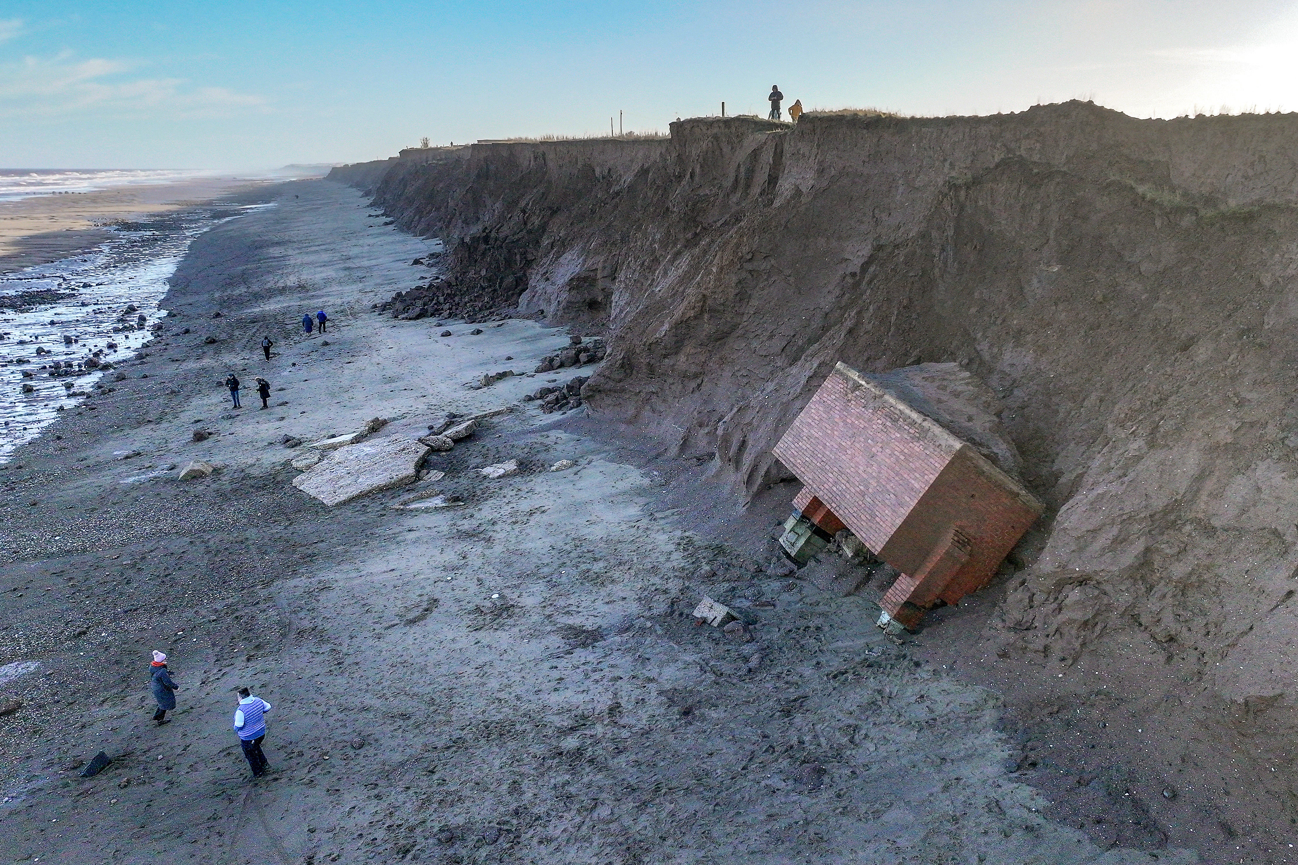
On the Yorkshire coast in Tunstall, a decommissioned nuclear bunker crashed onto a beach as the cliff eroded, while waves lashed at the coast across the south west of England, causing part of a historic Teignmouth Grand Pier crumbled into the sea in Devon overnight. On Saturday morning, the Teignmouth National Coastwatch Institution said they had “never seen it this rough before” even with over an hour ahead of high tide.
Meanwhile, parts of a sea wall that protects the railway line in Dawlish “just crumbled” after a “very dramatic” night, resident Peter Large told the BBC.
“The wall is now gone at either end,” he said. “I’m looking down at it now and there’s a strip about 80 to 90 ft long where the wall has just crumbled. The waves are still crashing over the railway line and over the wall.”

Met Office five-day weather forecast:
Today and tonight:
Cloudy for many with outbreaks of rain and heavy showers. Further hill snow is likely across parts of northeast Scotland. A few brighter breaks developing at times in the south. Lighter winds for most compared to Saturday.
Largely cloudy with patchy outbreaks of rain, generally easing. Wintry showers mostly in the northeast, with mist and fog patches developing in any cloud breaks in the southeast.
Monday:
Generally cloudy with further outbreaks of rain for northeast England and east Scotland, wintry over the hills. A band of rain and strong winds arriving in the west and spreading eastwards.
Outlook for Tuesday to Thursday:
Remaining unsettled throughout, with rain, showers and possible hill snow moving across the country with strong winds, particularly on Tuesday when another deep area of low pressure arrives. Feeling cold.


