


The UK has recorded a new hottest day of the year so far as temperatures soar amid a heatwave.
The Met Office said was a provisional temperature of 33.2C had been measured in Charlwood, Surrey on Saturday.
The new high comes after Thursday saw the mercury hit 32.2C in Kew, west London – the previous hottest day of 2025 so far – as the country sweltered under an amber heat-health alert.

On Friday, a temperature of 30.8C was reached, triggering an official heatwave across England and Wales after three consecutive days of hot weather.
The amber heat-health warning from the UK Health Security Agency (UKHSA), covering all regions of England, remains in place until 9am on Monday.
The alert, issued for the first time since September 2023, warns “significant impacts are likely” across health and social care services because of high temperatures, including a rise in deaths, particularly among those aged 65 and over or people with health conditions.
Meanwhile, the Met Office said scattered thunderstorms are set to mix with the continued high temperatures, potentially bringing “frequent lightning, large hail and gusty winds”, along with a chance of flooding.
The yellow thunderstorm weather warning covering all of northern England, from Nottingham up to above Newcastle, is in force from 3pm on Saturday until 4am the following day.
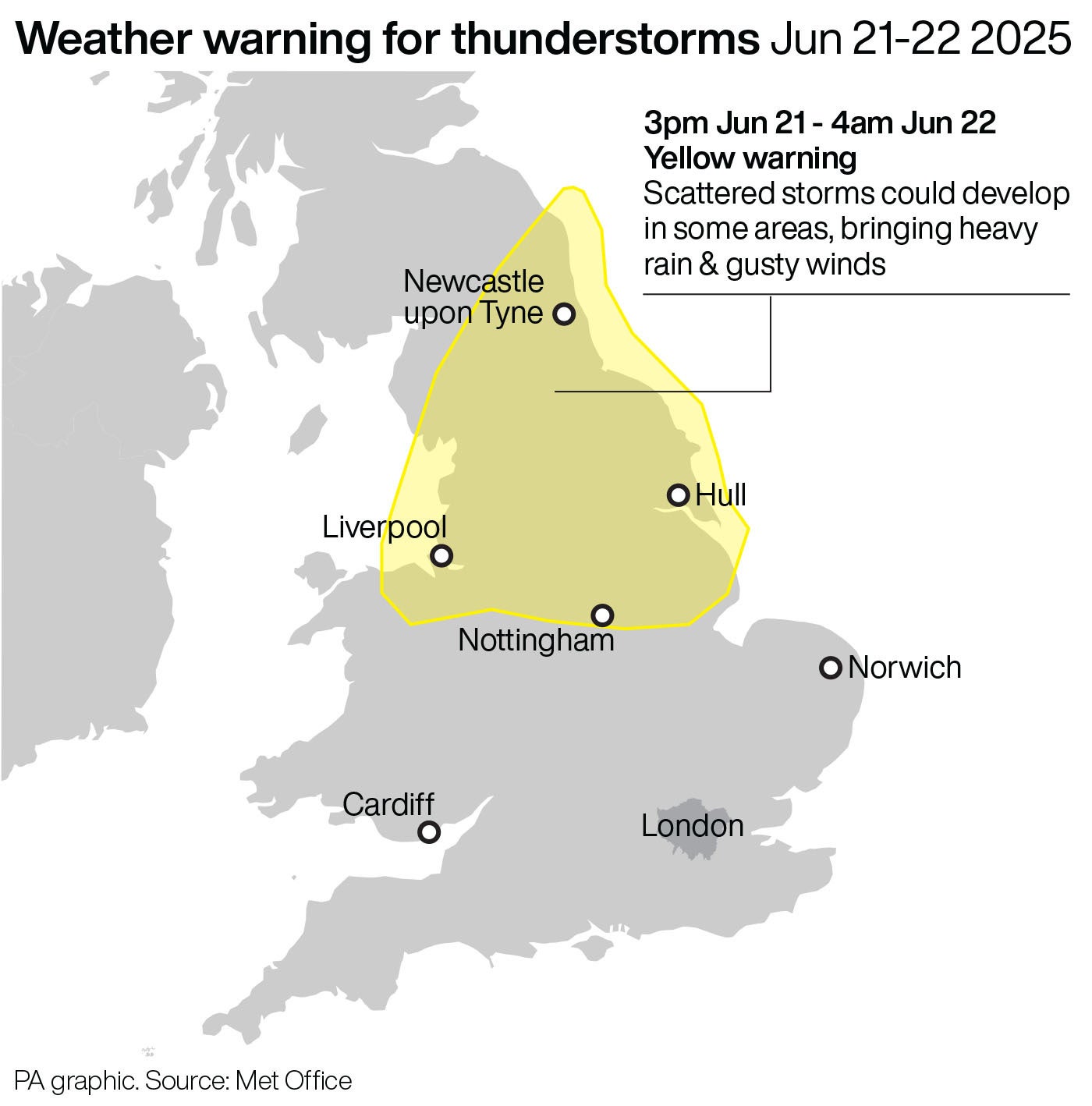
Up to 40mm of rain could fall in less than two hours, the forecaster said, as it urged those in the warning areas to consider whether their location is at risk of flash flooding and to prepare accordingly.
The alert, which includes Manchester, Derbyshire and Newcastle upon Tyne, is in place from 5pm on Saturday until 3am on Sunday.
In an online forecast, Met Office meteorologist Jonathan Vautrey said: “Provisionally, Northern Ireland has recorded its warmest June night on record, Friday into Saturday, and this hot and humid air is being dragged up a little bit from parts of continental Europe, but we also have low pressure out in the Atlantic, and that is driving weather fronts across the UK, providing instability in the air and the perfect conditions to start sparking off some thunderstorms as that hot and humid air rises rapidly.”
As Saturday continues there may be “sharp showers” heading north, accompanied by “a few rumbles of thunder” during daylight hours with “sunny spells” in between, he added.
“Both Wales, Northern Ireland and Scotland all recorded their warmest day of 2025 yesterday.
“For the latter two, it is going to be a slightly less warm day today, a touch fresher, but still certainly around the mid 20s is possible for parts of Northern Ireland and into central areas of Scotland,” Mr Vautrey said.
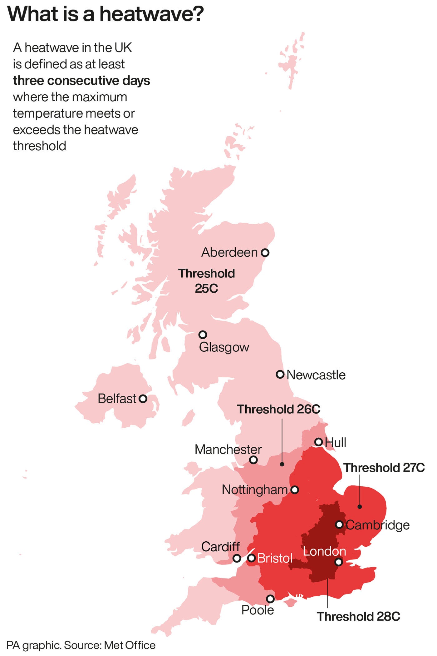
An official heatwave is recorded when areas reach a certain temperature for three consecutive days, with thresholds varying from 25C to 28C in different parts of the UK.
“Many places” in England and “one or two areas” in Wales, including Cardiff, entered a heatwave following Friday’s highest temperatures, Becky Mitchell, meteorologist at the Met Office, said.
An amber heat-health alert, issued by the UK Health Security Agency (UKHSA) for the first time since September 2023, for all regions in England remains in place over the weekend.
The agency has warned that significant impacts are likely across health and social care services, including an increase in demand, during the alert period.
Sunday will see a day of “sunny spells and showers” with highs of around 27C and 28C, Met Office weather forecaster Dan Stroud said.
Conditions are expected to feel “a lot fresher” in the west of the UK whilst remaining “very warm and humid” in the east, he added.
“For the vast majority of the country, the temperature is going to be much, much closer to the mid, late June average.
“As we move our way through Sunday night into Monday, it’s going to feel a lot fresher for us all, a lot more comfortable sleeping conditions.”
