UK TimesUK Times
  • Home
  • News
  • TV & Showbiz
  • Money
  • Health
  • Science
  • Sports
  • Travel
  • More
    • Web Stories
    • Trending
    • Press Release
What's Hot

Oscar-winning Palestinian director Basel Adra says his home in West Bank raided by Israeli soldiers – UK Times

13 September 2025

M61 northbound exit for A666 | Northbound | Road Works

13 September 2025

Dallas Cowboys star Tyler Smith becomes highest-paid NFL guard ever with historic $96m contract extension

13 September 2025
Facebook X (Twitter) Instagram
UK TimesUK Times
Subscribe
  • Home
  • News
  • TV & Showbiz
  • Money
  • Health
  • Science
  • Sports
  • Travel
  • More
    • Web Stories
    • Trending
    • Press Release
UK TimesUK Times
Home » Met Office weather warning for strong winds of up to 80mph to hit England and Wales – UK Times
News

Met Office weather warning for strong winds of up to 80mph to hit England and Wales – UK Times

By uk-times.com13 September 2025No Comments3 Mins Read
Facebook Twitter LinkedIn Telegram Pinterest Tumblr Reddit WhatsApp Email
Share
Facebook Twitter LinkedIn Pinterest Email

Get the free Morning Headlines email for news from our reporters across the world

Sign up to our free Morning Headlines email

Sign up to our free Morning Headlines email

Morning Headlines

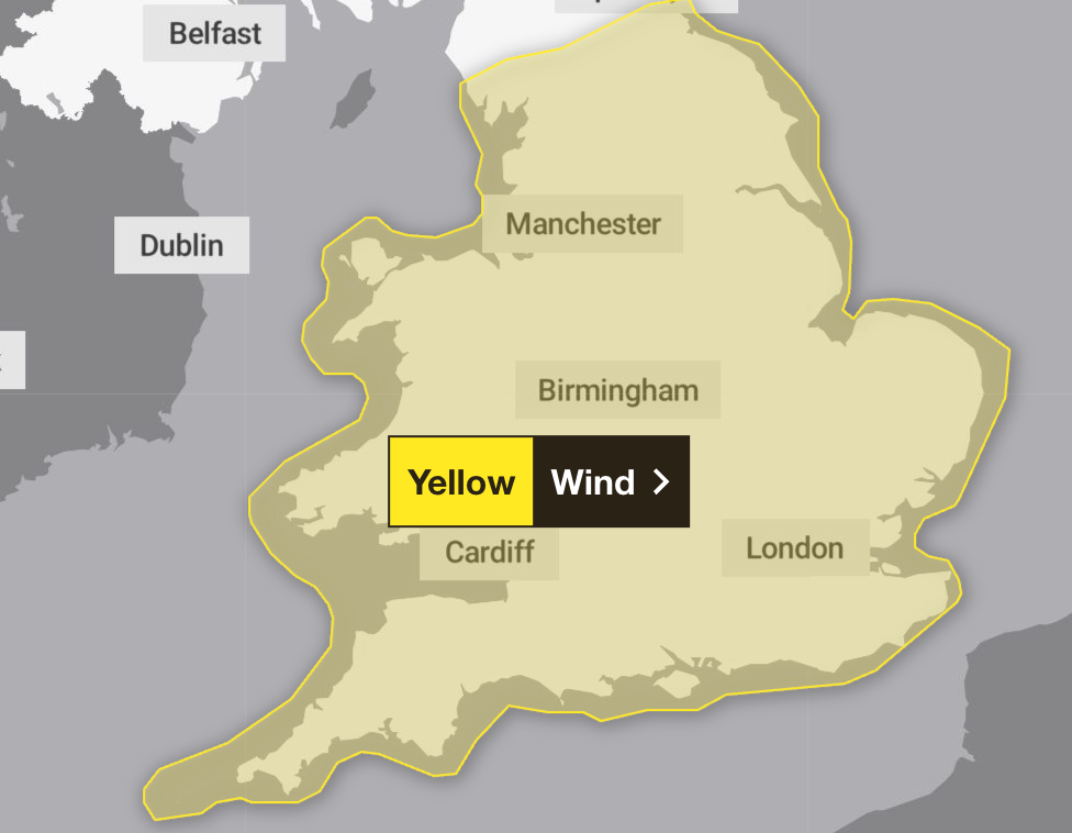
The Met Office has issued a yellow weather warning for wind across most parts of England and Wales from Sunday evening into Monday.

Forecasters say most of England and all of Wales could see strong winds and thunderstorms.

The high winds could lead to potential disruption and delays to road, rail, air, and ferry transport, with a chance that some roads and bridges may close, the forecaster has said.

There is also a chance that power cuts may occur, with the potential to affect other services, such as mobile phone coverage.

The yellow warning issued by Met Office for England and Wales

The yellow warning issued by Met Office for England and Wales (Met office)

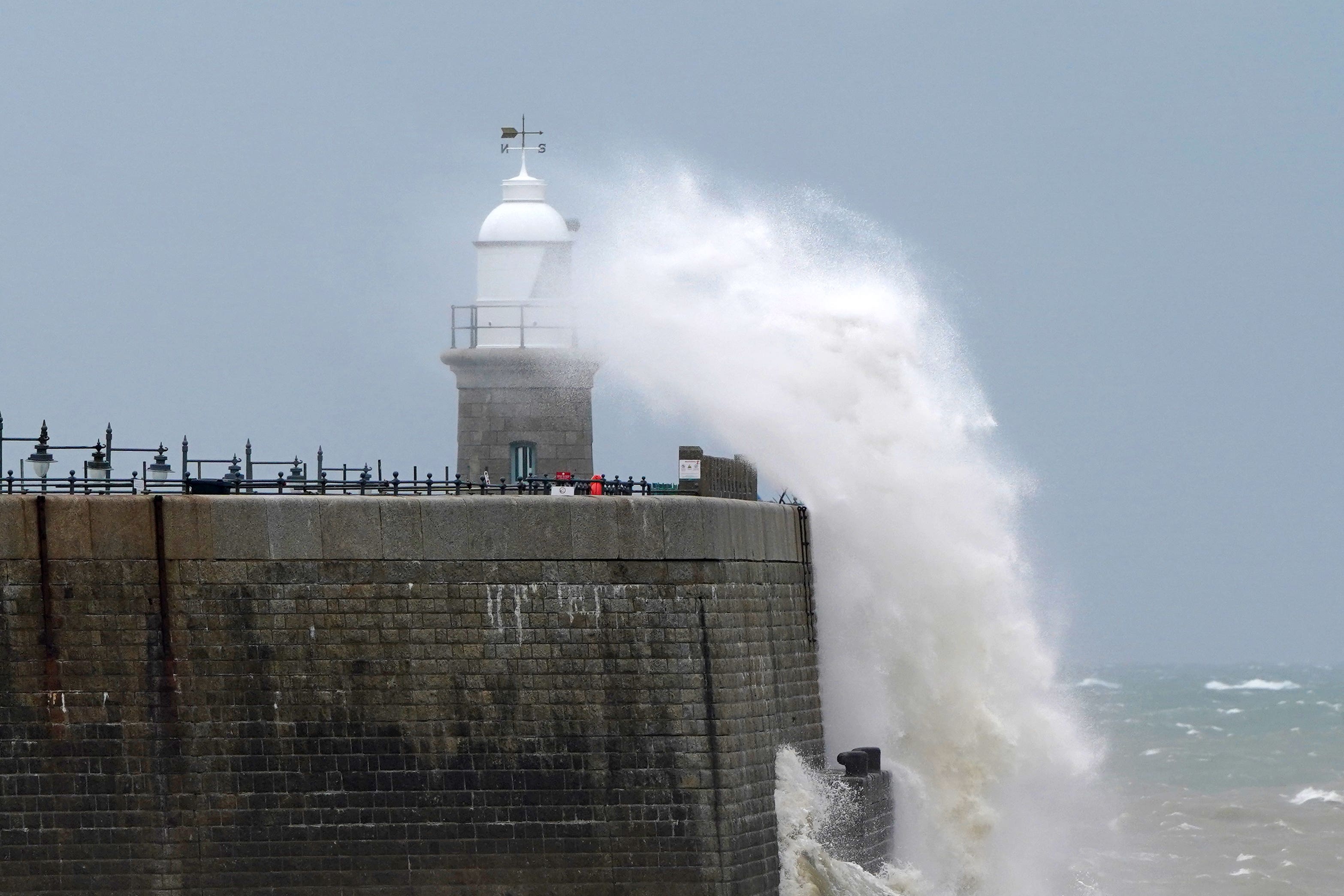
Some communities near coastal routes and sea fronts may be affected by large waves.

The yellow weather warning is in place from 8pm on Sunday until 6pm on Monday, across London and South East England, the East of England, East Midlands, West Midlands, Yorkshire and Humber, North East England, North West England, South West England and Wales.

Gusts of around 50mph to 60mph are likely around coasts and hills, and 70mph to 80mph is possible in the most exposed locations, with the windiest conditions expected on Monday morning.

Forecasters said those affected should prepare to protect their property and people from injury. They recommend checking for loose items outside the home and planning how to secure items such as bins, garden furniture, trampolines, tents, sheds and fences.

’Strong and gusty winds’ and possible thunderstorms are expected on Sunday and into Monday evening

’Strong and gusty winds’ and possible thunderstorms are expected on Sunday and into Monday evening (PA Wire)

They also advise checking road conditions and bus and train timetables, and amending travel plans if necessary to have the best chance of avoiding delays.

Despite the unpredictable conditions, forecasters said they are not expecting a named storm to hit the country.

Paul Gundersen, chief meteorologist at the Met Office, said: “We have been monitoring a deepening area of low pressure over the North Atlantic that might bring impactful weather to the UK, most likely on Sunday and Monday. At present, a named storm is unlikely.”

Forecasters said they are not expecting a named storm to hit the country

Forecasters said they are not expecting a named storm to hit the country (PA)

Met Office outlook:

Saturday

A day of sunny spells and scattered blustery showers, some heavy or thundery and merging into longer spells of rain at times. Breezy and gusty for most, but a little less so than on Friday. Temperatures near average for September.

Saturday evening

Showers mostly dying out and winds easing. Turning chilly under clear spells, particularly in the north, with rural grass frost and isolated fog patches. Clouding over in the southwest later.

Sunday

A fine start for many but with rain then spreading northeastwards, heavy at times. Turning increasingly windy with gales developing widely across England and Wales into the evening.

Monday to Wednesday

Staying windy for many on Monday with sunny spells and blustery showers, possibly heavy and thundery. Showers and winds gradually easing on Tuesday, but turning unsettled again on Wednesday.

Share. Facebook Twitter Pinterest LinkedIn Tumblr Telegram Email

Related News

Oscar-winning Palestinian director Basel Adra says his home in West Bank raided by Israeli soldiers – UK Times

13 September 2025

M61 northbound exit for A666 | Northbound | Road Works

13 September 2025

Newport drug dealer caught after WhatsApp chat | UK News

13 September 2025

Trump administration could deploy 1,000 troops to Louisiana cities until 2026, report says – UK Times

13 September 2025

M40 southbound between J4 and J3 | Southbound | Accident

13 September 2025

M61 southbound within J3 for A666 | Southbound | Road Works

13 September 2025
Top News

Oscar-winning Palestinian director Basel Adra says his home in West Bank raided by Israeli soldiers – UK Times

13 September 2025

M61 northbound exit for A666 | Northbound | Road Works

13 September 2025

Dallas Cowboys star Tyler Smith becomes highest-paid NFL guard ever with historic $96m contract extension

13 September 2025

Subscribe to Updates

Get the latest UK news and updates directly to your inbox.

© 2025 UK Times. All Rights Reserved.
  • Privacy Policy
  • Terms of use
  • Advertise
  • Contact Us

Type above and press Enter to search. Press Esc to cancel.

Go to mobile version