UK TimesUK Times
  • Home
  • News
  • TV & Showbiz
  • Money
  • Health
  • Science
  • Sports
  • Travel
  • More
    • Web Stories
    • Trending
    • Press Release
What's Hot

Solving the asylum question is suddenly even more urgent – UK Times

20 August 2025

A1(M) northbound between J40 and J41 | Northbound | Vehicle Obstruction

20 August 2025

M18 southbound within J4 | Southbound | Road Works

20 August 2025
Facebook X (Twitter) Instagram
UK TimesUK Times
Subscribe
  • Home
  • News
  • TV & Showbiz
  • Money
  • Health
  • Science
  • Sports
  • Travel
  • More
    • Web Stories
    • Trending
    • Press Release
UK TimesUK Times
Home » Mapping Hurricane Erin: Storm dramatically shifts trajectory after lashing the Caribbean with rain and high winds – UK Times
News

Mapping Hurricane Erin: Storm dramatically shifts trajectory after lashing the Caribbean with rain and high winds – UK Times

By uk-times.com20 August 2025No Comments4 Mins Read
Facebook Twitter LinkedIn Telegram Pinterest Tumblr Reddit WhatsApp Email
Share
Facebook Twitter LinkedIn Pinterest Email

The latest headlines from our reporters across the US sent straight to your inbox each weekday

Your briefing on the latest headlines from across the US

Your briefing on the latest headlines from across the US

Evening Headlines

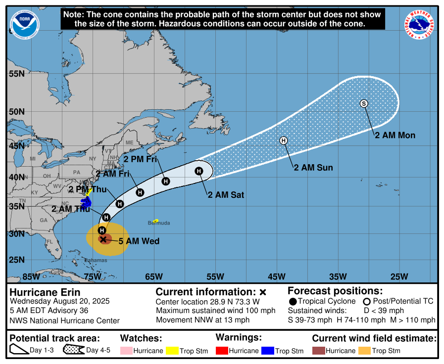
Hurricane Erin made a sudden shift in trajectory Wednesday as Category 2 winds raced towards the U.S. East Coast, resulting in closed beaches and a state of emergency being declared in North Carolina.

Days after 130mph winds and torrential rainfall battered the Caribbean and left tens of thousands of Puerto Ricans without power, fears grew that Erin would slam into the U.S. as a Category 2 hurricane this week. By midday the storm was approaching Category 3 classification.

In an advisory Wednesday morning, the National Hurricane Center in Miami confirmed the storm was unlikely to make U.S. landfall after veering northwest toward open waters.

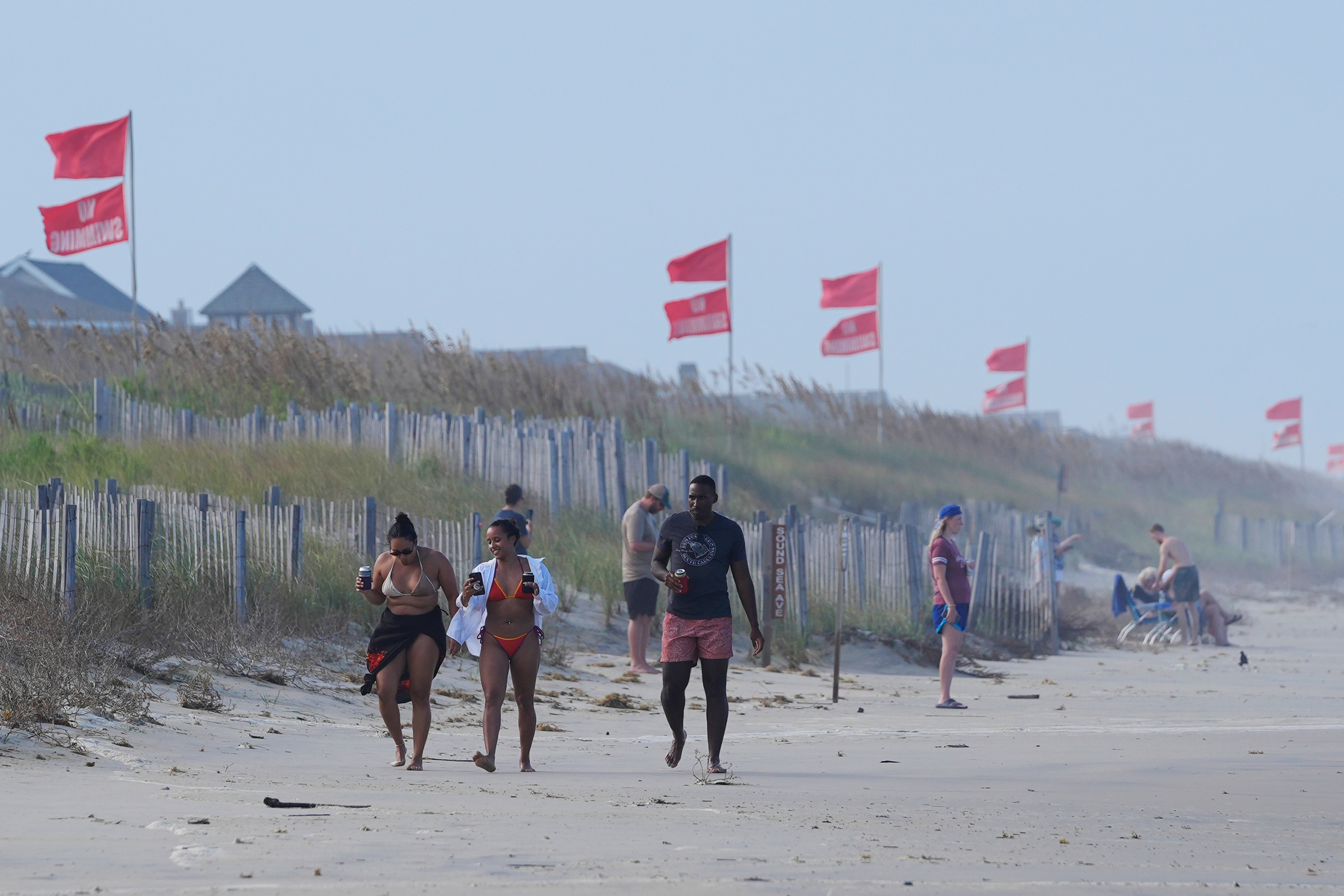
However, coastal states including Florida, New York, North Carolina and Virginia braced for impact, with swimming prohibited in “most” beaches.

Red flags, indicating swimming is prohibited, are raised at the beach in Duck, North Carolina, on Tuesday. Hurricane Erin made a sudden shift in trajectory as Category 2 winds raced towards the U.S. East Coast, resulting in closed beaches and a state of emergency being declared in the Tar Heel State

Red flags, indicating swimming is prohibited, are raised at the beach in Duck, North Carolina, on Tuesday. Hurricane Erin made a sudden shift in trajectory as Category 2 winds raced towards the U.S. East Coast, resulting in closed beaches and a state of emergency being declared in the Tar Heel State (AP)

Storm surge flooding and tropical storm conditions were present Outer Banks area of North Carolina, forcing state Governor Josh Stein to declare a state of emergency. “Right now, I want to emphasize the importance of taking this storm seriously, because it’s a serious storm and conditions can deteriorate quickly,” Stein told a morning press conference.

Lifeguards in North Carolina made more than 75 rescues from rip currents along the Wrightsville area coastline on Monday, prompting a no-swim order through Friday, according to the Wilmington Star-News.

Mandatory evacuations were ordered for Hatteras Island and Ocracoke Island in the Outer Banks ahead of the expected flooding, Stein said, adding that along with large swells, 4ft waves were expected to spill over sea walls, making some roads “impassable.”

“Turn around, don’t drown,” the governor said.

The National Hurricane Center illustrates the projected path of Hurricane Erin throughout the rest of the week

The National Hurricane Center illustrates the projected path of Hurricane Erin throughout the rest of the week (National Hurricane Center)

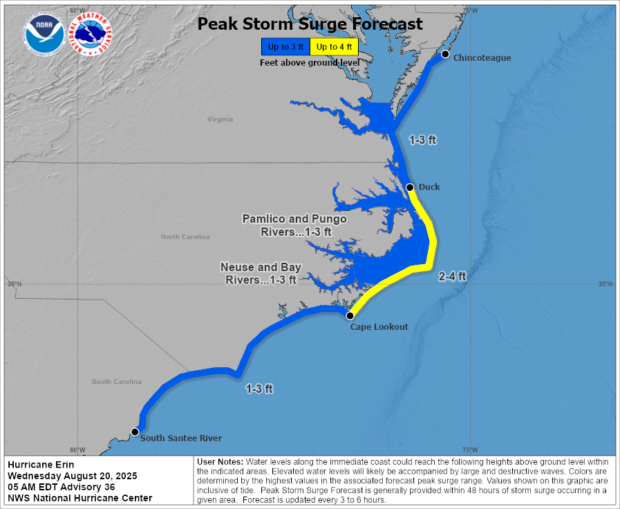
The storm surge will be accompanied by large waves, some up to 20ft high, and the possibility of flooding, according to the NOAA National Hurricane Center.

NOAA added that tropical storm conditions are expected on Thursday along the Virginia coast, with tropical storm force gusts likely along portions of the remainder of the U.S. Mid-Atlantic and southern New England coasts Thursday through early Friday.

While the East Coast has so far been spared the cyclone’s full force, the NHC issued a blizzard of warnings, including “life-threatening surf and rip currents” for the U.S., Bahamas, Bermuda, and Atlantic Canada throughout this week.

Dangerous storm surge flooding and tropical storm conditions could batter North Carolina

Dangerous storm surge flooding and tropical storm conditions could batter North Carolina (National Hurricane Center)

New York City closed its beaches to swimming on Wednesday and Thursday, and Governor Kathy Hochul ordered three state beaches on Long Island to prohibit swimming through Thursday.

Off Massachusetts, Nantucket Island could see waves of more than 10 feet later this week.

The worst conditions were expected late Wednesday through Thursday as the eye of the storm is likely to be at the closest point to the coast, carving a path between the East Coast and Bermuda.

Erin is expected to grow with tropical-storm-force winds extending 265 miles from its center before it is expected to begin weakening by Friday, the agency said.

Satellite images released by NASA shows Hurricane Erin moving away from the U.S. coast

Satellite images released by NASA shows Hurricane Erin moving away from the U.S. coast (AP)

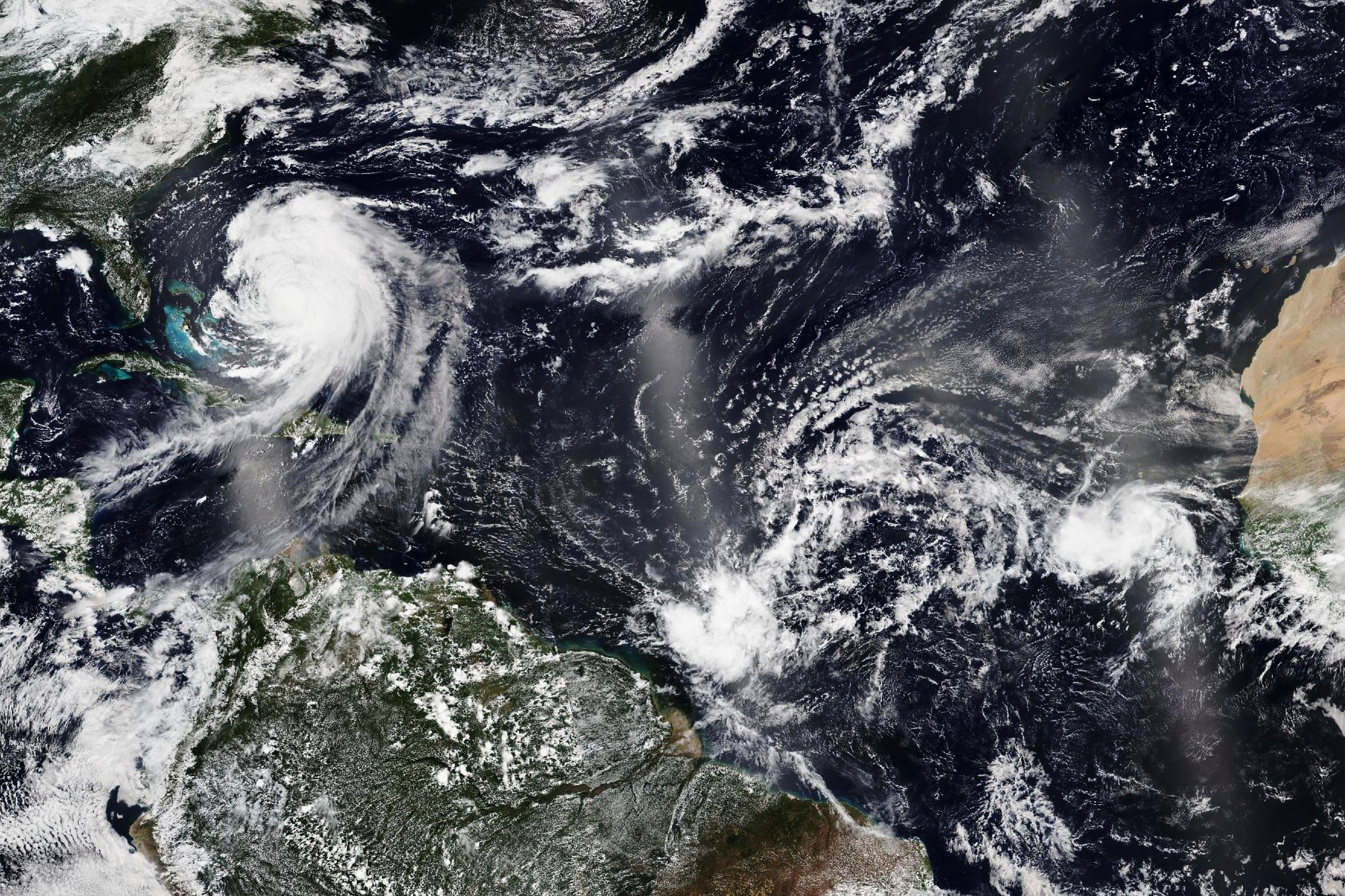
Satellite imagery and reports from a U.S. Air Force Hurricane Hunter aircraft indicated that Erin “is getting better organized, and slow strengthening is expected through Thursday night.”

Erin, the first Atlantic hurricane of 2025, exploded to a ferocious Category 5 on Saturday before being downgraded to a Category 3 early Sunday morning, then regaining strength again later in the day.

The storm brought flooding, rainfall, high surf, and strong winds across Puerto Rico, the Virgin Islands, and the northern Leeward Islands.

By Tuesday, it lashed the Turks and Caicos Islands, where government services were suspended and residents were ordered to stay home, along with parts of the Bahamas.

Share. Facebook Twitter Pinterest LinkedIn Tumblr Telegram Email

Related News

Solving the asylum question is suddenly even more urgent – UK Times

20 August 2025

A1(M) northbound between J40 and J41 | Northbound | Vehicle Obstruction

20 August 2025

M18 southbound within J4 | Southbound | Road Works

20 August 2025

The US Navy is spending millions on testing new drone technology. Setbacks have been significant – UK Times

20 August 2025

M1 northbound within J40 | Northbound | Broken down vehicle

20 August 2025

Trump’s new co-FBI deputy director once tried to subpoena abortion patients’ records – UK Times

20 August 2025
Top News

Solving the asylum question is suddenly even more urgent – UK Times

20 August 2025

A1(M) northbound between J40 and J41 | Northbound | Vehicle Obstruction

20 August 2025

M18 southbound within J4 | Southbound | Road Works

20 August 2025

Subscribe to Updates

Get the latest UK news and updates directly to your inbox.

© 2025 UK Times. All Rights Reserved.
  • Privacy Policy
  • Terms of use
  • Advertise
  • Contact Us

Type above and press Enter to search. Press Esc to cancel.

Go to mobile version