


The UK is set to see snow once again after the Met Office issued a yellow weather warning this week.
As much as 15cm of snow could fall in Wales and the West Midlands on Wednesday and Thursday, the Met Office has warned.
Delays and cancellations to public transport and flights are expected as well as delays to driving times with stranded vehicles and passengers.
The forecaster also warned some rural communities could be cut off and there is a chance of power cuts mobile phone coverage could be affected.
The yellow weather warning is in place from Wednesday at 4pm until Thursday at 4pm. Wales, the West Midlands, parts of Oxfordshire and Gloucestershire are also affected by the warning.
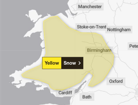
Forecasters have said 2-5 cm of snow could accumulate quite widely above 150-200 metres, with perhaps as much as 10-15 cm above 250-300 metres in mid and southeast Wales, as well as Herefordshire and Shropshire.
Some small accumulations of snow, typically less than 2 cm, are possible on lower ground, especially from later Wednesday evening into the early hours of Thursday morning.
Strong east to northeasterly winds are also expected to accompany the wet weather.
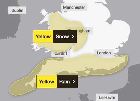
A yellow weather warning has also been issued for rain across the south of England from Wednesday at 6am to Thursday 8am.
Heavy rain across Sussex and Kent all the way to Cornwall could lead to flooding and disruption to travel. But snow is also likely in higher ground over Wednesday night across this region.
As much as 20mm of rain is expected quite widely with a few places near the south coast seeing 20-30 mm and perhaps as much as 50 mm over Dartmoor, according to the Met Office.
Strong winds will accompany the rain and snow and large waves could affect some east-facing coasts, especially along the English Channel.
This is a breaking story, more to follow…
.png?trim=0,1,0,895&width=1200&height=800&crop=1200:800 "Stay safe online with Bitdefender antivirus – UK Times")


