


The UK experienced its hottest summer ever in 2025, the Met Office has confirmed, with the country seeing record-breaking temperatures, long spells of sunshine and four official heatwaves.
Following the heat, rumours of a so-called Indian Summer – a period of unseasonably warm and calm weather that occurs in the autumn – had surfaced, with speculation that the mercury could hit 30C in the UK early in September.
But Met Office forecasters said they are expecting moderate conditions, with temperatures more likely to be in the low-twenties – which will still feel warm, but is normal for this time of year.
Met Office meteorologist Craig Snell said the current forecast suggests “nothing like what we have seen during the summer months.”
He told The Independent: “The week after next is a little bit too early to nail down exactly what will go on. Our general trend though, as we go through to the second week of September, is that, on the whole, for the UK, it is probably going to remain on the changeable, unsettled side of the weather.
“It looks like there will be some drier and brighter spells at times… It will be early September, so in any sunnier moments, it will still feel fairly warm out there.”
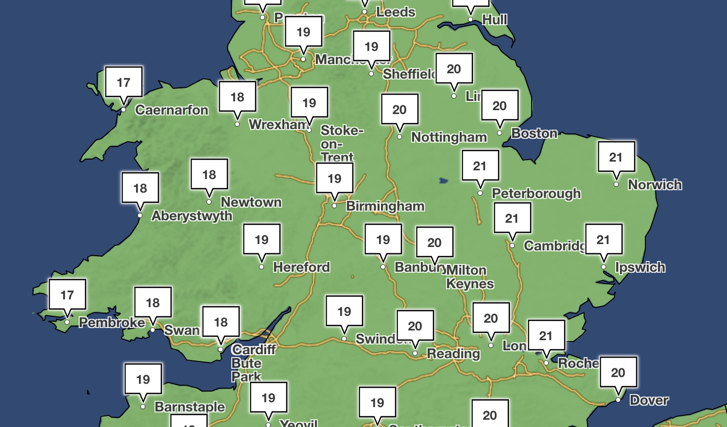
He said that, as the UK heads into the second week of September, it is likely to see the best of the brighter and drier weather, but there are no indications that temperatures will reach any highs that point towards a heatwave.
“I can’t say it’s not going to completely not happen, but looking at the chances of things happening, I’d say there’s just as much chance of us being as we are now,” he said.
The Met Office said that, between September 4 and 13, it expects “changeable and unsettled weather conditions” across the UK.
“This will mean showers or longer spells of rain will affect much of the UK at times,” it said. “Some heavy rain or showers are expected in places, most often in the west. Thunderstorms and hail are also possible, as are some spells of strong winds if any deep areas of low pressure form in the vicinity of the UK.
“Some short-lived spells of drier and more settled weather are also possible at times, especially later in the period when they may last a little longer. Temperatures will likely be close to average or slightly below overall, but may rise above at times in any drier, sunnier spells.”
The UK experienced an unprecedented summer this year, officially the hottest ever on record. It has seen four consecutive heatwaves this summer, which the Met Office says makes it “almost certainly” the warmest yet.
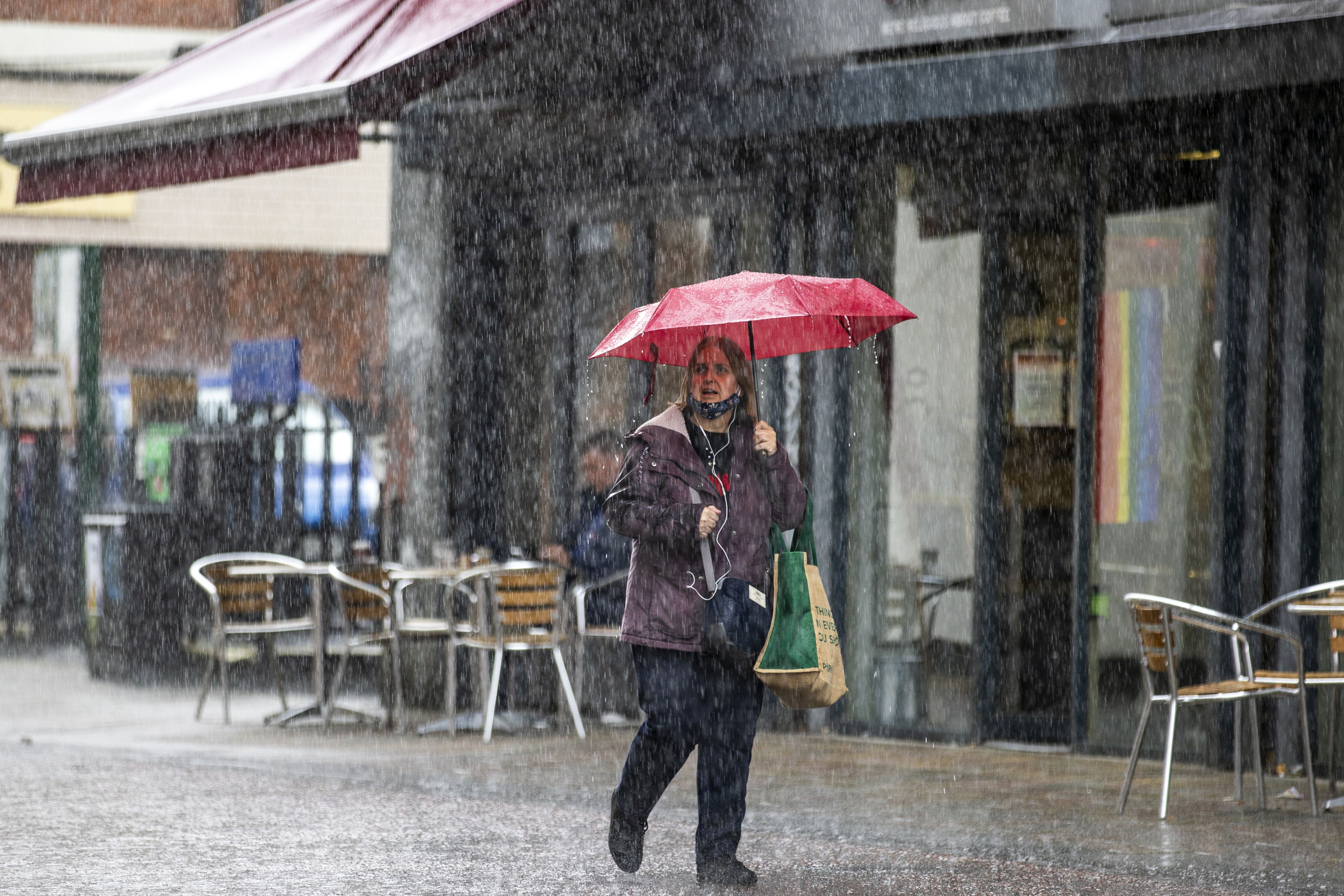
But as the UK faces the aftermath of Hurricane Erin, Britons are seeing an end to the dry spell that brought record-breaking temperatures to the UK all summer.
The double effects of Tropical Storm Fernand and Hurricane Erin have meant “unseasonable” rains for parts of the country.
Here is the weather forecast in the UK for the coming days, according to the Met Office.
Today
Rain will move eastwards across southern counties of England and Wales. Elsewhere will see a mixture of sunny spells and scattered showers. Lighter winds and maximum temperatures near average.
Tonight
Showers continue in the northwest. Cloud and rain, heavy at times, developing over much of England and Wales during the early hours. Becoming windy in the south with coastal gales.
Wednesday
Brisk winds and outbreaks of heavy rain will spread northeast on Wednesday, with heavy and blustery showers following behind. Temperatures remaining near average but tempered somewhat by the strong winds.
Thursday to Saturday
Sunny spells and heavy showers return on Thursday, before a slightly drier and brighter day for many on Friday. Further rain arriving in the northwest on Saturday. Average around temperatures.


