UK TimesUK Times
  • Home
  • News
  • TV & Showbiz
  • Money
  • Health
  • Science
  • Sports
  • Travel
  • More
    • Web Stories
    • Trending
    • Press Release
What's Hot

Sanex shower gel advert banned over racial stereotype – UK Times

21 August 2025

Controversial footy great turned radio host is accused of trying to turn AFL star Izak Rankine into the VICTIM after he hit opponent with a homophobic slur

21 August 2025

M4 eastbound between J11 and J10 | Eastbound | Broken down vehicle

21 August 2025
Facebook X (Twitter) Instagram
UK TimesUK Times
Subscribe
  • Home
  • News
  • TV & Showbiz
  • Money
  • Health
  • Science
  • Sports
  • Travel
  • More
    • Web Stories
    • Trending
    • Press Release
UK TimesUK Times
Home » Here’s why NASA wants your photos of hurricane damage – UK Times
News

Here’s why NASA wants your photos of hurricane damage – UK Times

By uk-times.com21 August 2025No Comments3 Mins Read
Facebook Twitter LinkedIn Telegram Pinterest Tumblr Reddit WhatsApp Email
Share
Facebook Twitter LinkedIn Pinterest Email

The latest headlines from our reporters across the US sent straight to your inbox each weekday

Your briefing on the latest headlines from across the US

Your briefing on the latest headlines from across the US

Evening Headlines

NASA is launching a pilot program to harness citizen science for faster hurricane disaster recovery.

The space agency, in collaboration with the Global Learning and Observations to Benefit the Environment (GLOBE) Program, a science and education initiative, is spearheading a new Response Mapper project.

This innovative initiative will utilize photographs submitted by the public, both before and after a disaster, to track ground conditions in affected areas.

Throughout the summer and fall, NASA is actively encouraging public participation in the program, especially from residents in the Southeast, the region most often devastated by tropical storms, hurricanes, and related flooding.

“Your contributions could ultimately help emergency managers make faster and better-informed decisions when it matters most and strengthen your community’s ability to respond and recover from disasters,” NASA said.

NASA wants members of the public to send in photos before and after damage from hurricanes and other major storms, such as here in Asheville, North Carolina after Hurricane Helene in 2024

NASA wants members of the public to send in photos before and after damage from hurricanes and other major storms, such as here in Asheville, North Carolina after Hurricane Helene in 2024 (Getty Images)

These time-stamped and geotagged images will be shared directly with emergency responders, complementing existing data from satellites and field reports, according to the space agency.

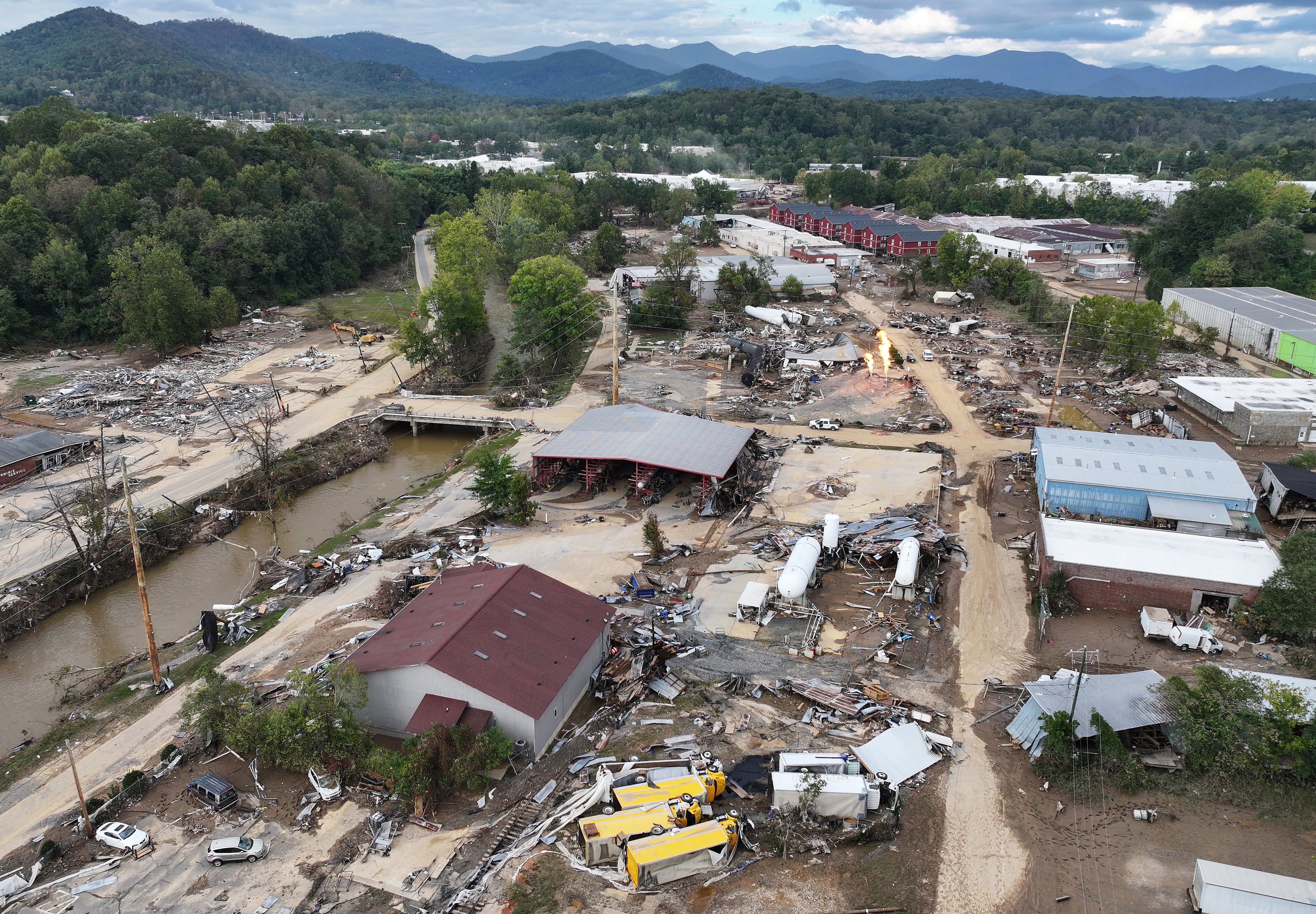
Disaster response teams often face challenges when obtaining “clear, localized” information, especially in rural areas, NASA said.

Satellite imagery offers a broad view of hazards but may overlook short-lived impacts due to factors such as cloud cover, timing of the orbit, or data processing delays. Satellites can also overlook finer details that photos taken closer to the ground could capture.

“We’re exploring how citizen science can support disaster response in ways that Earth observation data alone can’t,” said Kristen Okorn, a coordinator for NASA’s Disasters Response Coordination System, in a statement.

“A single photo of land cover, whether it is a flooded street, fallen trees, or even an undamaged area, can offer helpful context.”

Sea water pushed inland by Hurricane Erin surges under the Cape Hatteras Motel in Buxton, North Carolina. NASA wants Americans to help document damage from tropical storms

Sea water pushed inland by Hurricane Erin surges under the Cape Hatteras Motel in Buxton, North Carolina. NASA wants Americans to help document damage from tropical storms (AP)

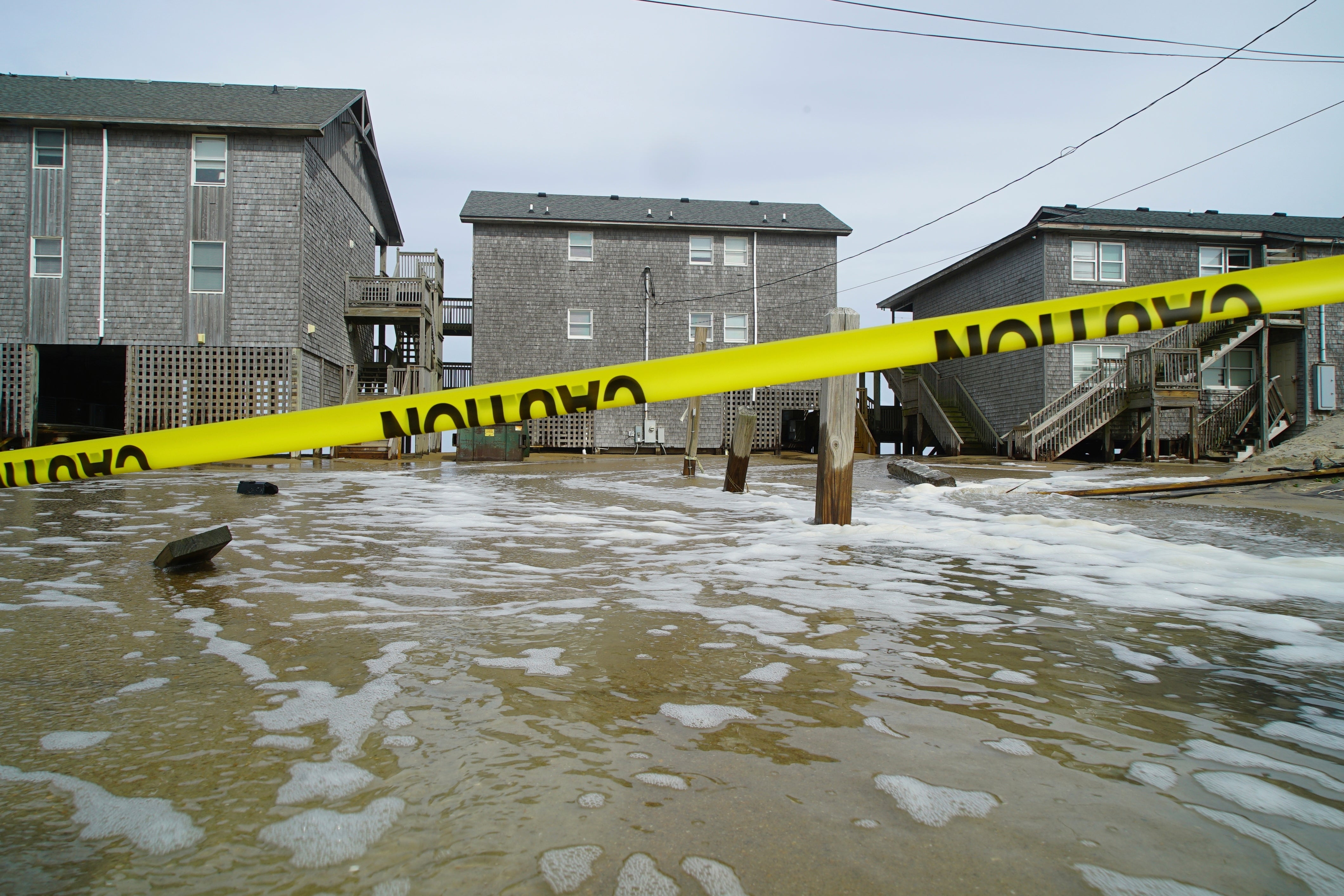
Such photos can be combined with other observations to help verify the situation on the ground, determining where cleanup crews are needed or assessing other impacts such as crop losses or potential further threats to public safety.

Citizens can share photos by downloading the GLOBE Observer app on their smartphones and joining the NASA Response Mappers team.

The agency stresses that there is an inherent risk during hurricane season and members of the public should never put themselves in danger to take photos, particularly when collecting data in the midst of or immediately after a severe storm.

Data collection is requested in areas of the south and southeast United States, including the states of Texas, Louisiana, Mississippi, Alabama, Tennessee, Kentucky, Georgia, Florida, North Carolina, South Carolina, and Virginia, as well as Puerto Rico and the U.S. Virgin Islands.

Share. Facebook Twitter Pinterest LinkedIn Tumblr Telegram Email

Related News

Sanex shower gel advert banned over racial stereotype – UK Times

21 August 2025

M4 eastbound between J11 and J10 | Eastbound | Broken down vehicle

21 August 2025

Transfer news live: Arsenal hijack Eze deal, Newcastle’s Wissa bid rejected, Chelsea to sign Enciso, Isak latest – UK Times

21 August 2025

A66 eastbound between A1150 and A1027 | Eastbound | General Obstruction

21 August 2025

What is the fairest way to tax property in the UK? Join The Independent Debate – UK Times

21 August 2025

Jack Draper’s mixed US Open run ends in defeat as doubles specialists win $1m prize – UK Times

21 August 2025
Top News

Sanex shower gel advert banned over racial stereotype – UK Times

21 August 2025

Controversial footy great turned radio host is accused of trying to turn AFL star Izak Rankine into the VICTIM after he hit opponent with a homophobic slur

21 August 2025

M4 eastbound between J11 and J10 | Eastbound | Broken down vehicle

21 August 2025

Subscribe to Updates

Get the latest UK news and updates directly to your inbox.

© 2025 UK Times. All Rights Reserved.
  • Privacy Policy
  • Terms of use
  • Advertise
  • Contact Us

Type above and press Enter to search. Press Esc to cancel.

Go to mobile version